Wednesday 12 October 2022

BRIDGES OVER RIVERS AND CENTURIES

Here I am taking you on  a journey over bridges, spanning over two centuries  in the Scottish Borders  - from the 18th century to the present day. What  struck me in writing this post  is the length of time - i.e. 200 years - that many of these old bridges have served their  community, before replacement structures were built  - progress sometimes seems very slow! 
 
Craigsford Bridge over the Leader Water at Earlston   was built around 1737.  Until the building of the new toll road at the end of the century, it was the main route to Edinburgh.  It was sometimes referred to as the Mill Brig,   being close to the Simpson & Fairbairn Mill that produced textiles until its closure in 1969.


 The graceful late 18th century Carolside Bridge spanning the Leader Water at Earlston   links the neighbouring estates of Carolside and Leadervale.   *


"The Statistical Account of Scotland" of 1834  gives us a beautiful description of Carolside  

"Poised on a green plateau beside the River Leader and sheltered by surrounding slopes of its own extensive woodlands, as a sweet and secure asylum from the toils and troubles of the world'."
Two views of the bridge in more recent times: 
 

  A view of the Leader valley, looking down on the little Carolside Bridge on the  left of the photograph.


The Three Leaderfoot Bridges, near Melrose in the Scottish Borders. built 1776, 1865, and 1974.


An unusual view of the three bridges *  - the middle lower  road bridge was  built 1776-80.  It replaced a ferry crossing over the River Tweed,  on the route that is now the main road north to Edinburgh.  Its narrow structure, more used to horses and carts, remained in use for 200 years (controlled by traffic lights) until  a new road bridge spanned the river in 1974. 

 
The famous Leaderfoot Viaduct built in 1865 was the major engineering feat of the Berwickshire Railway Line from the east.   The statistics are impressive -  the viaduct stands 126 feet (38 m) from the floor of the river valley, and  its 19 arches, each has a 43 feet span.  

The Berwickshire Railway was badly affected by severe flooding in 1948 and services were restricted to good only.    The last train ran over the viaduct in 1965.  It  is  now  under the care of Historic Environment Scotland.  

The Viaduct  remains a  popular spot for  photographers today  -  the  view taken from the old road bridge which is now only open to walkers and cyclists.  
 
 
Lowood Bridge is a narrow sandstone arch bridge, built some 250 years ago. It spans the River Tweed and is a vital transport link for the surrounding area, carrying  around 5k vehicles per day, controlled by traffic lights.    It has recently underdone major repairs.


Coldstream Bridge over the River Tweed was opened  in 1767 and marks the boundary between Scotland and England  - and is still the main route south today.

Coldstream Bridge02 2000-01-03.jpg 

Coldstream Bridge Tollhouse at the north end of the bridge,  was more than just the location for collecting taxes.  For it was akin to Gretna Green towards the west as  the location for a Scottish  "Irregular Marriage".  This was in the form of a verbal declaration by the couple  giving their consent  before witnesses and did not require a clergyman, but anyone who took on the role for a fee.  No notice, such as banns,  was required, no parental consent  and no residency requirement.  Such marriages were valid in Scotland but were increasingly frowned upon and became less  and less acceptable. 

In the meantime, however, many English couples in particular,   eloped to places just across the Border,  to escape the stricter English marriage laws and obtain a quick, easy  and cheaper marriage.     

 It was on the bridge that Scottish bard  Robert Burns had his first glimpse of England, as marked  by a plaque. 


The Rennie Bridge over the River Tweed at Kelso was built in 1893  to replace one washed away in floods of 1797. Designed by John Rennie, it was an earlier and smaller scale version of his  Waterloo Bridge in London.


The Toll House, where the payment had to be made, was the scene of a riot in 1854, when  local people   objected to continuing to pay the tolls when the building costs had been long cleared. It still took three years for tolls to be withdrawn. For nearly 200 years, this narrow bridge  remained the only bridge across the Tweed at Kelso, causing many a bottleneck, until the building of a new one in 1998 to the east of the town.

The Chain Bridge at Melrose beneath  the Eildon Hills crosses the famous salmon river of the Tweed.   It was opened  in 1826 as a footbridge.

Conditions were imposed on  its use including the restraint that no more than eight people should be on it at any one time and  "no loitering, climbing or intentional swinging" permitted.  Contravention of the rules was  punishable by a £2 fine (£135 in today's money) -  or imprisonment.  (Currency Converter)

 Since payment had to be made to cross the bridge, a ford downstream for horse drawn vehicles continued to be used by pedestrians for some time, with a box of stilts at each end of the ford for people to use for a safer journey,


Mertoun Bridge, near St. Boswells was built c.1840, replacing an earlier  partly wooden construction.   It was later replaced in 1886 with he 5 arch sandstone bridge  we see today.


* With thanks to the Auld Earlston Group for the use of these two photographs. 


****************

Saturday 13 August 2022

August has to mean Holidays - and Beaches.

Oh, I do like to be besides the sea
I do like to stroll along the Prom, Prom Prom
Where the big brass band plays "tiddly  om pom pom......
  
  So says the popular music hall song, written in 1907.  I feel the same way, so follow me across Scotland and the North of England to view photographs of my favourite beaches - with some added fascinating facts.
 
I am a Blackpudlian - born in the famous north west seaside resort of Blackpool, Lancashire,  famed for its golden beaches and its tower, modelled on the Eiffel Tower. Built in 1894, Blackpool Tower  rises to 520 feet - facts drummed into us at school. 
 

 Until the 19th century, Blackpool was just a small hamlet.  It rose to prominence with the building of the railway linking  it to the mill towns of industrial Lancashire and Yorkshire and soon became England's  most popular  holiday resort, with its miles of golden sands. The unique Blackpool Illuminations were first switched on in 1879 to extend  the season well into the autumn


A view from the top of the tower, looking down on two of the three piers

Blackpool Tower  was the entertainment complex of its day, with its  Ballroom (where my parents met),  circus ring, aquarium and zoo. We used to go there about once a year as a treat.

These photograph were taken in early April  - hence the quiet beaches.

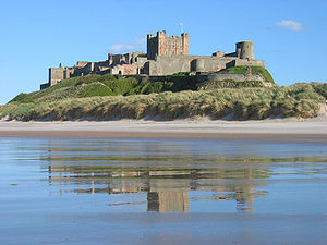
 Sometimes people have the misguide impression  of the north east of England as one of empty shipyards and mining communities.  But the Northumberland Coast is beautiful - as here in a peaceful scene of  the beach by Bamburgh Castle (below). 

M

As a child I remember having a book on heroines in history with an illustration of Grace Darling  (1815-1842), the lighthouse keeper's daughter at Bamburgh,   who in 1838 risked storms and icy seas to rescue sailors from the shipwrecked "Forfarshire".  She died of consumption just four years later and is buried in Bamburgh, with a museum dedicated to her life.


 The view on a fine day from the castle ramparts over to the Farne Islands.  

 Also on the English north east coast is South Shields, in County Durham - my husband's birthplace.   


Marsden Rock is a 100 foot sea stack which lies 100 yards off the cliff face off South Shields, county Durham.   Believed to be once  a smugglers' haunt,  it is now the home of seabird colonies.   In 1803 a flight of steps was constructed up the side of the rock. In 1903 several choirs climbed onto the rock to perform a choral service.   My husband spent his childhood here, with the beach a favourite playground. In a way this is an historic photograph, as in 1996 the arch collapsed, splitting the rock into two stacks. The smaller stack was decreed unsafe and demolished.    

Robin Hood's Bay in North Yorkshire is a picturesque old fishing village.  The origin of its name is obscure as it is long way from Nottingham, traditionally the home of the legendary Robin Hood. The village, with its steep narrow streets leading down to the sea,  was known as a smuggler's haunt in the 18th century. 

Head north now to Scotland.


The wide sweep of the beach at North Berwick, 20 miles south of Edinburgh in East Lothian.  Taken on a quiet June day.

Canty Bay,  near North Berwick.  In the distance in the middle of the  Firth of Forthis the prominent Bass Rock, an island with its lighthouse and seabird colonies. an island in he middle of the  the Firth of Forth,    On the right is the prominent Bass Rock with its lighthouse and seabird colonies.  An early Christian hermit is said to have settled here.  A castle was later built there which in the 17th century was used to house prisoners - an isolated, windy, inhospitable, exposed spot with little chance of escape. 


 Castle Sands at St. Andrew's, Fife. St Andrew's Castle, built around 1200,  was the official residence of Scotland’s leading bishop (and later archbishop) throughout the Middle Ages. Its size signalled the power and wealth of these important churchmen. The fortress repeatedly exchanged hands between the Scots and the English in several battles but  St Andrews Castle suffered significant damage during the Wars of Independence with England (1296–1356). It  was left without a resident or a purpose when bishops were abolished in 1592. It fell rapidly into ruin.

Across to the other side of the country:


Rockcliffe Bay on the Solway coast of south west Scotland was our destination for a short break on the trail of my husband's ancestors.

And finally to the Isle of Iona off the west coast of Scotland. 


 A beautiful, peaceful beach to ourselves amidst the wonderful scenery on the Isle of Iona, looking across to the Isle of Mull in the Scottish West Highlands.


Not the razz-ma-tazz seaside of my opening ditty - 

but beautiful beaches that stay in my memory.

 Copyright © 2022 · Susan Donaldson.  All Rights Reserved  

Tuesday 12 July 2022

CALMING, PEACEFUL, WATERS

Feeling hot and bothered. stressed and weary, then take a look at these images of calm, peaceful waters - and relax.   
 
 
Ullswater in the Lake District, Cumbria

 Loch Etive in the West of Scotland,. near Oban. 


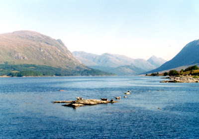
Two views here of Loch Awe in Argyll on the west coast of Scotland, taken in a misty  May morning  The loch, at 21 miles long,  is the third largest freshwater loch in Scotland.
 

Looking across from the Isle of Iona to the Isle of Mull off the west cost of Scotland
 
 
Oban Bay on the West Coast of Scotland 
 
 
The Skye Bridge linking the mainland with the island
 
Evening Light over the Isles of Mull and Iona.
 
Copyright © 2022 · Susan Donaldson.  All Rights Reserved   
 
  ****************


Sunday 29 May 2022

SCOTTISH ISLAND IDYLLS

The islands of Mull and Iona  are one of my most favourite places on the earth.  So join me  on my island journey recalling  many happy visits. 
 

 I feel this could be in the Greek Islands - but no  it was on Iona, looking across to the hills of Mull on a beautiful  day in September  - not your usual  image of Scotland! 

MULL   is the second largest island in  the inner Hebrides off the west coast of Scotland and a wonderful place for an "away from it all" holiday.   The Mull song says it all:

'The Isle of Mull is of isles the fairest,
Of ocean's gems 'tis the first and rarest;
Green grassy island of sparkling fountains,
Of waving woods and high tow'ring mountains."
 

Sailing out of Oban on the mainland at the start of our journey- a 45 minute sail where you pass the Lismore Lighthouse and are surrounded by just hills and water.


Lismore Lighthouse 
 
 
 Duart Castle is  the first sight on approaching Mull  by the the Ferry  - the 13th century ancestral home of the Clan McLean guarding  the entrance to the Sound of Mull
 
Landing at Craignure, we then travelled 50 miles on a single track road to Fionnphort,  the most westerly point on the island  -  a tiny village of some 70 residents with  one pub, one   shop,  one cafe, one seafood cabin, and the ferry office, gateway to the islands of Iona and Staffa.  

The first time I had seen such a sign!  


  From Fionphort looking across to Iona
 
At Fionnphort is  the ferry to Iona.  It is is only a 10 minute crossing, but can get surprisingly choppy in poor weather.  Only Iona residents can take their car across.  Despite  the number of   tourist that visit the island, it is amazing how quickly you can get away from them and often find yourself on your own on one of the many beaches. 


There is something very special about Iona and the peace and tranquillity you can experience there.   It is only  1.5 miles wide by 3 miles long, with a population of around 120 permanent residents, but everyone talks about  the magical nature of this   seat of Scottish Christianity where St. Columba founded his Abbey in 563AD. Later it became a place of pilgrimage and learning,   and over 40 of Scotland's earliest kings were buried there. The restored medieval abbey continues to hold daily services  and 48 kings of Scotland are reputed to be buried in the grounds. 
 
Church, Coast, Iona Abbey, Iona


"Deep peace of the running waves"
(A line from John Rutter's Gaelic Blessing) 


 Iona War Memorial

From Fionnphort, one day, we took the small boat trip out to Staffa. Besides going in the cave, we also climbed the rather precarious steps up to the top of the  island, with a rope to hold on to  as a safely aid, and saw whales swimming.  


Its most famous feature is Fingal's Cave,  a large sea cave located near the southern tip of the island some 60 feet high.   The sight  of the rocks and the sound of the sea inspired composer Felix Mendellsohn to capture his visit  in 1829 in "The Hebrides Overture". Other famous visitors made the journey there  - John Keats, Sir Walter Scott, Joseph Turner and Robert Louis Stevenson.  Queen Victoria and Prince Albert were rowed into the cave on the royal barge in 1847.


 Highland Cattle freely roam the village of Fionphort
  
 
One hungry  cow decided to take a nibble from the garden of our holiday cottage, so I dashed out to take a photograph. 
 

This young cow  stood motionless at the side of the road, very happy to pose for the visitors walking down to the ferry across to Iona.
                                             
 
 Two shop signs in  Tobermory - the principal village was the setting for the children's TV series "Balamory".  It  was built as a fishing port in the late 18th century and is   noted for its brightly painted buildings along the main street to the pie
 
 
And So Farewell to Mull


Did You Know? 
  • Calgary in Canada takes its name from Calgary on Mul

 ***********
 
Copyright © 2022 · Susan Donaldson.  All Rights Reserved  

BRIDGES OVER RIVERS AND CENTURIES

Here I am taking you on  a journey over bridges, spanning over two centuries  in the Scottish Borders   - from the 18th century to the pres...